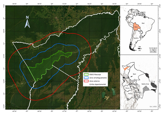
La huella del fuego: Un análisis multitemporal de las quemas forestales dentro y fuera de la Reserva Nacional de Vida Silvestre Amazónica Manuripi, Pando, Bolivia
The fire footprint: A multi-temporal analysis of forest fires inside and outside the Manuripi Amazon National Wildlife Reserve, Pando, Bolivia
DOI:
https://doi.org/10.56469/rae.v5i1.2189Palabras clave:
Amazonía, áreas protegidas, deforestación, densidad de Kernel, fuegoResumen
En este estudio, evaluamos la dinámica histórica de las quemas ocurridas durante el periodo 2001-2020 dentro y fuera de la Reserva Nacional de Vida Silvestre Amazónica Manuripi (RNVSA Manuripi), ubicada el norte de Bolivia. Incluimos variables físicas (focos de fuego, superficie quemada, deforestación y caminos), sociodemográficas (densidad poblacional) y bioclimáticas como el índice de vegetación de diferencia normalizada (NDVI) y las anomalías de precipitación y temperatura. Encontramos mayores quemas ocurridas fuera de la RNVSA Manuripi que dentro de ella. Las quemas estuvieron asociadas al final de la época seca (julio-septiembre) e inicio de la húmeda (octubre-noviembre), siendo los más críticos entre los meses de agosto y octubre, especialmente, septiembre. Las quemas estuvieron asociadas al bajo registro del NDVI, bajas precipitaciones y altas temperaturas. En algunos años, los focos de fuego y las superficies quemadas dentro y fuera de la RNVSA Manuripi estuvieron asociadas al fenómeno de El Niño. Por otra parte, las quemas también tuvieron relación con la deforestación y mantenimiento o apertura de caminos. Sugerimos que la actividad humana esta omnipresente dentro y fuera de la RNVSA Manuripi, especialmente, fuera de ella. Nuestros resultados demuestran una gestión eficiente de los administradores de la RNVSA Manuripi al evitar o disminuir las quemas, al menos para el periodo analizado. Futuras investigaciones podrían analizar las interacciones específicas entre el fuego, las presiones humanas y las condiciones bioclimáticas a escala de la RNVSA Manuripi y su zona de amortiguación.
Citas
Aparicio J, Ocampo M, Aguilar-Kirigin AJ, Miranda-Calle AB, Ríos-Ríos JN, Paredes-Rodríguez MA. (2021). Reptiles y Anfibios de Sara Ana. In: Ripa-Landajo M, Naoki K, editors. Historia Natural de Sara Ana: Estación experimental agroecológica de Alto Beni, Bolivia. La Paz, Bolivia: Plural editores; p. 249–269.
AppEEARS. 2025. AppEEARS [Internet]. [accessed 2025 Apr 7]. https://appeears.earthdatacloud.nasa.gov/
Bishop, M.P., James, L.A., Shroder, J.F. and Walsh, S.J. (2012), “Geospatial teAparicio J, Ocampo M, Aguilar-Kirigin AJ, Miranda-Calle AB, Ríos-Ríos JN, Paredes-Rodríguez MA. 2021. Reptiles y Anfibios de Sara Ana. In: Ripa-Landajo M, Naoki K, editors. Historia Natural de Sara Ana: Estación experimental agroecológica de Alto Beni, Bolivia. La Paz, Bolivia: Plural editores; p. 249–269.
AppEEARS. 2025. AppEEARS. (accessed 2025 Apr 7). https://appeears.earthdatacloud.nasa.gov/
Aragão LEOC, Anderson LO, Lima A, Arai E. (2016). Fires in Amazonia. In: Nagy L, Forsberg BR, Artaxo P, editors. Interactions Between Biosphere, Atmosphere and Human Land Use in the Amazon Basin [Internet]. Berlin, Heidelberg: Springer; (accessed 2020 Apr 17); p. 301–329. https://doi.org/10.1007/978-3-662-49902-3_13
Benzing A, van der Ent A, Casey LW, Luna M, Luna E, Quispe R, Durán F, Choquehuanca M, Ledesma C. (2022). High natural bromine concentrations in organic Brazil Nuts from Bolivia. Journal of Food Composition and Analysis. 110:104533. https://doi.org/10.1016/j.jfca.2022.104533
Buitrago Romero R, Breniére Simone F, Taborga Manrique X, Quispe Aruhuito R, Revollo Zepita S. 2016. Identificación genética del agente causal y el insecto vector de la enfermedad de chagas circulante en la Amazonía boliviana: Provincia Iturralde. Revista CON-CIENCIA. 4(1):93–103.
Butrón Ledezma SL. (2011). Adicionalidad y áreas protegidas: efecto de las áreas protegidas nacionales sobre la deforestación en las tierras bajas de Bolivia (1991 - 2005). Tesis de Maestría. Turrialba, Costa Rica: Centro Agronómico Tropical de Investigación y Enseñanza (CATIE). (accessed 2022 Dec 27). https://repositorio.catie.ac.cr/handle/11554/4403
Caúla RH, Oliveira-Júnior JF, Lyra GB, Delgado RC, Heilbron Filho PFL. 2015. Overview of fire foci causes and locations in Brazil based on meteorological satellite data from 1998 to 2011. Environ Earth Sci. 74(2):1497–1508. https://doi.org/10.1007/s12665-015-4142-z
Chuvieco E, Opazo S, Sione W, Valle H del, Anaya J, Bella CD, Cruz I, Manzo L, López G, Mari N, et al. (2008). Global Burned-Land Estimation in Latin America Using Modis Composite Data. Ecological Applications. 18(1):64–79. https://doi.org/10.1890/06-2148.1
Curt T, Aini A, Dupire S. (2020). Fire Activity in Mediterranean Forests (The Algerian Case). Fire. 3(4):58. https://doi.org/10.3390/fire3040058
Denis DJ. (2020). Univariate, Bivariate, and Multivariate Statistics Using R: Quantitative Tools for Data Analysis and Data Science. John Wiley & Sons.
ESRI. (2016). ArcGIS Desktop 10.5. Redlands, CA: Environmental Systems Research Institute.
FAN (Fundación Amigos de la Naturaleza). (2022). Sistema de monitoreo y alerta temprana de riesgos de incendios forestales (SATRIFO). SATRIFO (accessed 2022 Dec 26). http://incendios.fan-bo.org/
Fearnside PM. 2008. Amazon Forest maintenance as a source of environmental services. Anais da Academia Brasileira de Ciências. 80(1):101–114. https://doi.org/10.1590/S0001-37652008000100006
Filho H de O, Oliveira-Júnior JF de, Silva MV da, Jardim AM da RF, Shah M, Gobo JPA, Blanco CJC, Pimentel LCG, da Silva C, da Silva EB, et al. (2022). Dynamics of Fire Foci in the Amazon Rainforest and Their Consequences on Environmental Degradation. Sustainability. 14(15):9419. https://doi.org/10.3390/su14159419
FIRMS. (2025). NASA-FIRMS (accessed 2025 Apr 7). https://firms.modaps.eosdis.nasa.gov/map/
Fonseca M.G, Anderson L.O, Arai E, Shimabukuro YE, Xaud HAM, Xaud MR, Madani N, Wagner FH, Aragão LEOC. (2017). Climatic and anthropogenic drivers of northern Amazon fires during the 2015–2016 El Niño event. Ecological Applications. 27(8):2514–2527. https://doi.org/10.1002/eap.1628
Fotheringham AS, Brunsdon C, Charlton M. (2000). Quantitative geography: Perspectives on spatial data analysis. SAGE.
Geldmann J, Joppa LN, Burgess ND. (2014). Mapping Change in Human Pressure Globally on Land and within Protected Areas. Conservation Biology. 28(6):1604–1616. https://doi.org/10.1111/cobi.12332
GeoBolivia. (2025). GeoBolivia. (accessed 2025 Apr 7). https://geo.gob.bo/catalogue/#/datasets
GEOGPSPERU. (2025). MTC - Red Vial Vecinal - Descarga Gratis - Shapefile - ArcGis - QGIS - WGS84. (accessed 2025 Apr 7). https://www.geogpsperu.com/2015/09/mtc-red-vial-vecinal-descarga-gratis.html
GIOVANNI. (2025). GIOVANNI The bridge between data and science version 4.40. (accessed 2025 Apr 7). https://giovanni.gsfc.nasa.gov/giovanni/
Golding N, Betts R. (2008). Fire risk in Amazonia due to climate change in the HadCM3 climate model: Potential interactions with deforestation. Global Biogeochemical Cycles. (accessed 2021 May 27) 22(4). https://doi.org/10.1029/2007GB003166
Gould KA, Fredericksen TS, Morales F, Kennard D, Putz FE, Mostacedo B, Toledo M. (2002). Post-fire tree regeneration in lowland Bolivia: implications for fire management. Forest Ecology and Management. 165(1):225–234. https://doi.org/10.1016/S0378-1127(01)00620-X
Granato D, Santos JS, Escher GB, Ferreira BL, Maggio RM. (2018). Use of principal component analysis (PCA) and hierarchical cluster analysis (HCA) for multivariate association between bioactive compounds and functional properties in foods: A critical perspective. Trends in Food Science & Technology. 72:83–90. https://doi.org/10.1016/j.tifs.2017.12.006
Hansen MC, Potapov PV, Moore R, Hancher M, Turubanova SA, Tyukavina A, Thau D, Stehman SV, Goetz SJ, Loveland TR, et al. (2013). High-Resolution Global Maps of 21st-Century Forest Cover Change. Science. 342(6160):850–853. https://doi.org/10.1126/science.1244693
HDX. (2025). Humanitarian Data Exchange, Find & Use Crisis Data. (accessed 2025 Apr 7). https://data.humdata.org/
Holden Z. A, Swanson A, Luce C. H, Jolly W. M, Maneta M, Oyler JW, Warren D. A, Parsons R, Affleck D. (2018). Decreasing fire season precipitation increased recent western US forest wildfire activity. PNAS. 115(36):E8349–E8357. https://doi.org/10.1073/pnas.1802316115
Huffman G. J, Bolvin D. T, Nelkin E. J, Wolff D. B, Adler R. F, Gu G, Hong Y, Bowman K. P, Stocker E. F. (2007). The TRMM Multisatellite Precipitation Analysis (TMPA): Quasi-Global, Multiyear, Combined-Sensor Precipitation Estimates at Fine Scales. Journal of Hydrometeorology. 8(1):38–55. https://doi.org/10.1175/JHM560.1
Jin M, Dickinson R. E. (2010). Land surface skin temperature climatology: benefitting from the strengths of satellite observations. Environ Res Lett. 5(4):044004. https://doi.org/10.1088/1748-9326/5/4/044004
Kaiser H. F. (1960). The Application of Electronic Computers to Factor Analysis. Educational and Psychological Measurement. 20(1):141–151. https://doi.org/10.1177/001316446002000116
Keeley J. E, Pausas J. G, Rundel PW, Bond WJ, Bradstock RA. (2011). Fire as an evolutionary pressure shaping plant traits. Trends in Plant Science. 16(8):406–411. https://doi.org/10.1016/j.tplants.2011.04.002
Maillard O, Vides-Almonacid R, Flores-Valencia M, Coronado R, Vogt P, Vicente-Serrano SM, Azurduy H, Anívarro R, Cuellar RL. (2020). Relationship of Forest Cover Fragmentation and Drought with the Occurrence of Forest Fires in the Department of Santa Cruz, Bolivia. Forests. 11(9):910. https://doi.org/10.3390/f11090910
Mamuse A, Porwal A, Kreuzer O, Beresford S. (2009). A new method for spatial centrographic analysis of mineral deposit clusters. Ore Geology Reviews. 36(4):293–305. https://doi.org/10.1016/j.oregeorev.2009.06.001
Marengo JA, Nobre CA, Tomasella J, Oyama MD, Oliveira GS de, Oliveira R de, Camargo H, Alves LM, Brown IF. (2008). The Drought of Amazonia in 2005. Journal of Climate. 21(3):495–516. https://doi.org/10.1175/2007JCLI1600.1
Marengo JA, Tomasella J, Alves LM, Soares WR, Rodriguez DA. (2011). The drought of 2010 in the context of historical droughts in the Amazon region. Geophysical Research Letters. 38(12). https://doi.org/10.1029/2011GL047436
Masuoka E, Fleig A, Wolfe RE, Patt F. (1998). Key characteristics of MODIS data products. IEEE Transactions on Geoscience and Remote Sensing. 36(4):1313–1323. https://doi.org/10.1109/36.701081
MMAyA (Ministerio de Medio Ambiente y Aguas). (2022). Sistema de información y monitoreo de bosques (SIMB). Sistema de información y monitoreo de bosques. (accessed 2022 Dec 27). https://simb.siarh.gob.bo/simb/
MMAyA (Ministerio de Medio Ambiente y Aguas), Servicio Nacional de Áreas Protegidas, Reserva Nacional de Vida Silvestre Amazónica Manuripi. (2013). Plan de manejo de la Reserva Nacional de Vida Silvestre Amazónica Manuripi 2012-2022.
Moscoso A. (2003). Desarrollos legales e institucionales sobre áreas protegidas y zonas de amortiguamiento en Bolivia, Ecuador y Perú. In: Blanes J, Navarro RM, Drehwald U, Bustamante T, Moscoso Artuto, Muñoz F, Torres A, editors. Las zonas de amortiguamiento: un instrumento para el manejo de la biodiversidad El caso de Ecuador, Perú y Colombia. Quito; p. 35–105.
Mostacedo B, Balcazar J, Montero J.C. (2006). Tipos de bosque, diversidad y composición florística en la Amazonia sudoeste de Bolivia. Ecología en Bolivia. 41(2):99–116.
Nanzad L, Zhang J, Tuvdendorj B, Nabil M, Zhang S, Bai Y. (2019). NDVI anomaly for drought monitoring and its correlation with climate factors over Mongolia from 2000 to 2016. Journal of Arid Environments. 164:69–77. https://doi.org/10.1016/j.jaridenv.2019.01.019
Nepstad D, Schwartzman S, Bamberger B, Santilli M, Ray D, Schlesinger P, Lefebvre P, Alencar A, Prinz E, Fiske G, Rolla A. (2006). Inhibition of Amazon Deforestation and Fire by Parks and Indigenous Lands. Conservation Biology. 20(1):65–73. https://doi.org/10.1111/j.1523-1739.2006.00351.x
Oliveira-Júnior JF de, Mendes D, Correia Filho WLF, Silva Junior CA da, Gois G de, Jardim AM da RF, Silva MV da, Lyra GB, Teodoro PE, Pimentel LCG, et al. (2021). Fire foci in South America: Impact and causes, fire hazard and future scenarios. Journal of South American Earth Sciences. 112:103623. https://doi.org/10.1016/j.jsames.2021.103623
Parrish JD, Braun DP, Unnasch RS. (2003). Are We Conserving What We Say We Are? Measuring Ecological Integrity within Protected Areas. BioScience. 53(9):851–860. https://doi.org/10.1641/0006-3568
Pastana DNB, Modena É de S, Wadt LH de O, Neves E de S, Martorano LG, Lira-Guedes AC, Souza RLF de, Costa FF, Batista APB, Guedes MC. (2021). Strong El Niño reduces fruit production of Brazil-nut trees in the eastern Amazon. Acta Amaz. 51:270–279. https://doi.org/10.1590/1809-4392202003702
Pereira M, Figueiredo D. (2009). Effects of the Alqueva Dam Reservoir on the Distribution of Steppe Birds. Physical Geography. 30(1):43–63. https://doi.org/10.2747/0272-3646.30.1.43
QGIS Development Team. (2020). QGIS Geographic Information System: Open Source Geospatial Foundation Project. http://qgis.osgeo.org
Quintano C, Fernández-Manso A, Calvo L, Marcos E, Valbuena L. (2015). Land surface temperature as potential indicator of burn severity in forest Mediterranean ecosystems. International Journal of Applied Earth Observation and Geoinformation. 36:1–12. https://doi.org/10.1016/j.jag.2014.10.015
R Core Team. (2023). R: A Language and Environment for Statistical Computing. Vienna, Austria: R Foundation for Statistical Computing. https://www.R-project.org/
RAISG (Red Amazónica de Información Socioambiental Georreferenciada). (2025). Mapas. RAISG. (accessed 2025 Apr 7). https://www.raisg.org/es/mapas/
Reichle S. (2006). Distribution, diversity and conservation status of Bolivian amphibians. Unpublished Doktorgrades (Dr rer nat) dissertation, Rheinischen Friedrichs-Wilhelms-Universität, Bonn.
Resnikowski H. (2007). La detección de la reducción de bosques en Bolivia y las proyecciones futuras de la Superintendencia Forestal en Bolivia. Ecología en Bolivia. 42(1):1–3.
Rodrigues M, de la Riva J. (2014). An insight into machinelearning algorithms to model human-caused wildfire occurrence. Environmental Modelling & Software. 57:192–201. https://doi.org/10.1016/j.envsoft.2014.03.003
Rodríguez N, Armenteras D, Retana J. (2013). Effectiveness of protected areas in the Colombian Andes: deforestation, fire and land-use changes. Reg Environ Change. 13(2):423–435. https://doi.org/10.1007/s10113-012-0356-8
Rodriguez-Montellano A. (2012). Cartografía multitemporal de quemas e incendios forestales en Bolivia: Detección y validación post-incendio. Ecología en Bolivia. 47(1):53–71.
Sadiq A, Suleman M, Mohammed U. (2020). An estimation of rainfall anomaly index and its impact on crop production in Yola and environs. African Journal of Environment and Natural Science Research. 3(4):35–53.
SATRIFO (Sistema de Monitoreo y Alerta Temprana de Riesgos de Incendios Forestales ). (2025). SATRIFO 5.1 (accessed 2025 Apr 7). https://incendios.fan-bo.org/Satrifo/plataforma/
Schulze K, Knights K, Coad L, Geldmann J, Leverington F, Eassom A, Marr M, Butchart SHM, Hockings M, Burgess ND. (2018). An assessment of threats to terrestrial protected areas. Conservation Letters. 11(3):e12435. https://doi.org/10.1111/conl.12435
SENAMHI. (2021). Servicio Nacional de Meteorología e Hidrología, Estado Plurinacional de Bolivia. http://senamhi.gob.bo/index.php
Silvestrini RA, Soares-Filho BS, Nepstad D, Coe M, Rodrigues H, Assunção R. (2011). Simulating fire regimes in the Amazon in response to climate change and deforestation. Ecological Applications. 21(5):1573–1590. https://doi.org/10.1890/10-0827.1
Singh M, Sood S, Collins CM. (2022). Fire Dynamics of the Bolivian Amazon. Land. 11(9):1436. https://doi.org/10.3390/land11091436
Soliz A.A, Van Damme P.A, Macnaughton A, Carvajal F.M. (2014). Pesca indígena en la Amazonia boliviana: un estudio de caso en la Tierra Comunitaria de Origen Multiétnico II (Pando y Beni). In: MRE-MMAyA (Ministerio de Relaciones Exteriores - Ministero de Medio Ambiente y Agua), editor. Línea de base sobre ecosistemas y recursos acuáticos de la Amazonia boliviana en el marco de la evaluación de los impactos de las represas Jirau y Santo Antonio en territorio boliviano. Cochabamba - Bolivia: Editorial INIA; p. 295–337.
Veldman JW, Mostacedo B, Peña-Claros M, Putz FE. (2009). Selective logging and fire as drivers of alien grass invasion in a Bolivian tropical dry forest. Forest Ecology and Management. 258(7):1643–1649. https://doi.org/10.1016/j.foreco.2009.07.024
Wallace R, Painter R. (2000). Conservación de pecaríes en la Amazonía Boliviana: biodiversidad vs viabilidad poblacional. In: Cabrera E, Mercolli C, Resquin R, editors. Manejo de Fauna Silvestre en Amazonía y Latinoamérica. Asunción: CITES Paraguay; p. 263–271.
Watkins R.Z, Chen J, Pickens J, Brosofske KD. (2003). Effects of Forest Roads on Understory Plants in a Managed Hardwood Landscape. Conservation Biology. 17(2):411–419. https://doi.org/10.1046/j.1523-1739.2003.01285.x
van der Werf GR, Randerson JT, Giglio L, Gobron N, Dolman AJ. (2008). Climate controls on the variability of fires in the tropics and subtropics. Global Biogeochemical. 22(3). https://doi.org/10.1029/2007GB003122